
The massive system will move in on Sunday, Dec. 10, and continue into Monday, Dec. 11, according to the National Weather Service.
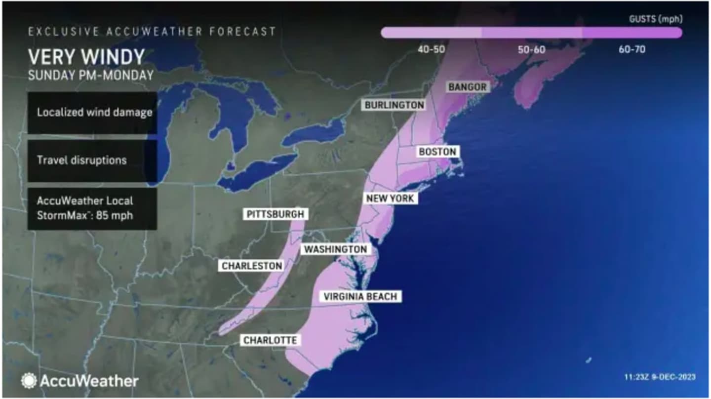
Sustained south-southeast winds of 25 to 35 miles per hour with gusts of 30 to 50 miles per hour are expected Sunday into Monday, with stronger gusts up to 60 miles per hour farther east, and up to 70 mph along the New England coast. (See the first image above from AccuWeather.com.)
In areas with the strongest wind gusts, scattered power outages are likely, and "trees and power lines, and numerous tree limbs could be downed," according to the National Weather Service. "Damage or blow away of poorly secured outdoor objects is expected."
A widespread 2 to 3 inches of rainfall is expected across the region.
The highest amounts of rainfall are forecast in the areas in the darker shade of green in the second image above, where up to 4 inches is expected with locally higher totals possible.
"Most of this rain will fall over 12 hours late Sunday afternoon into early Monday morning, before tapering off Monday morning," the National Weather Service said, adding, "There is potential for a narrow line of heavy downpours and embedded thunderstorms just ahead of the cold frontal passage Sun night/early Mon morning which could briefly bring enhanced rainfall rates and isolated 60 mph gusts."
A Flood Watch has been issued for coastal areas from Sunday afternoon through late Sunday night.
There is the potential for a changeover to light snow with light accumulation across interior areas on Monday morning.
Sunday will be mostly cloudy and breezy throughout the day. The chance for rainfall will start in the early afternoon and the high temperature will generally be in the mid-50s.
On Monday, winds will be shifting to the northwest early in the morning before the system moves out from west to east starting around midday Monday, followed by gradual clearing.
The passage of the cold front will usher in colder temperatures. Monday's high will be in the low 40s with the overnight low dipping to the upper 20s.
Tuesday, Dec. 12 will be mostly sunny and brisk with a high temperature of around 40 degrees.
The outlook for Wednesday, Dec. 13 calls for sunny skies with a high temperature in the upper 30s.
Check back to Daily Voice for updates.
Click here to follow Daily Voice Mount Vernon and receive free news updates.